
Imagine Herman Melville’s 1851 classic Moby Dick, as if it were the human genome.
The entrant has supplied multiple files for this work:
[1] [2]
-
 View projectMany diseases hold cyclical patterns as a result of climate changes throughout a year. Influenza, or 'the flu', causes the most illnesses in the colder, winter months. However, an outbreak of swine...
 -
 View projectCookies are one of the most misunderstood pieces of the modern web. While technically a cookie is just a simple text (.txt) file stored on your computer when you visit websites, its purposes are...
 -
 View projectIn a world of increasing inter-connectivity, programming languages form the foundation. This outlines the history of those languages.
 -
 View projectUnconsciously, the name "small steel teeth" has been with me for nearly two years, from the initial worry, tension, and some unacceptable; To later slowly adapt to slowly accustomed, and then to...
 -
 View projectHow is the world’s energy and electricity generated? What is the world’s largest power station? How does solar power compare to wind energy, geothermal energy or hydropower? How much of the world’s...
 -
 View projectThere's a good chance you experienced an earthquake today. Every day there are hundreds of thousands of earthquakes all over the world, except most are so small they are never felt. But what...
 -
 View projectInfographic devoted to one of the most impressive transportation services ever done. This poster is divided into three different sections: 787 fabrication, global impact, and important facts....
 -
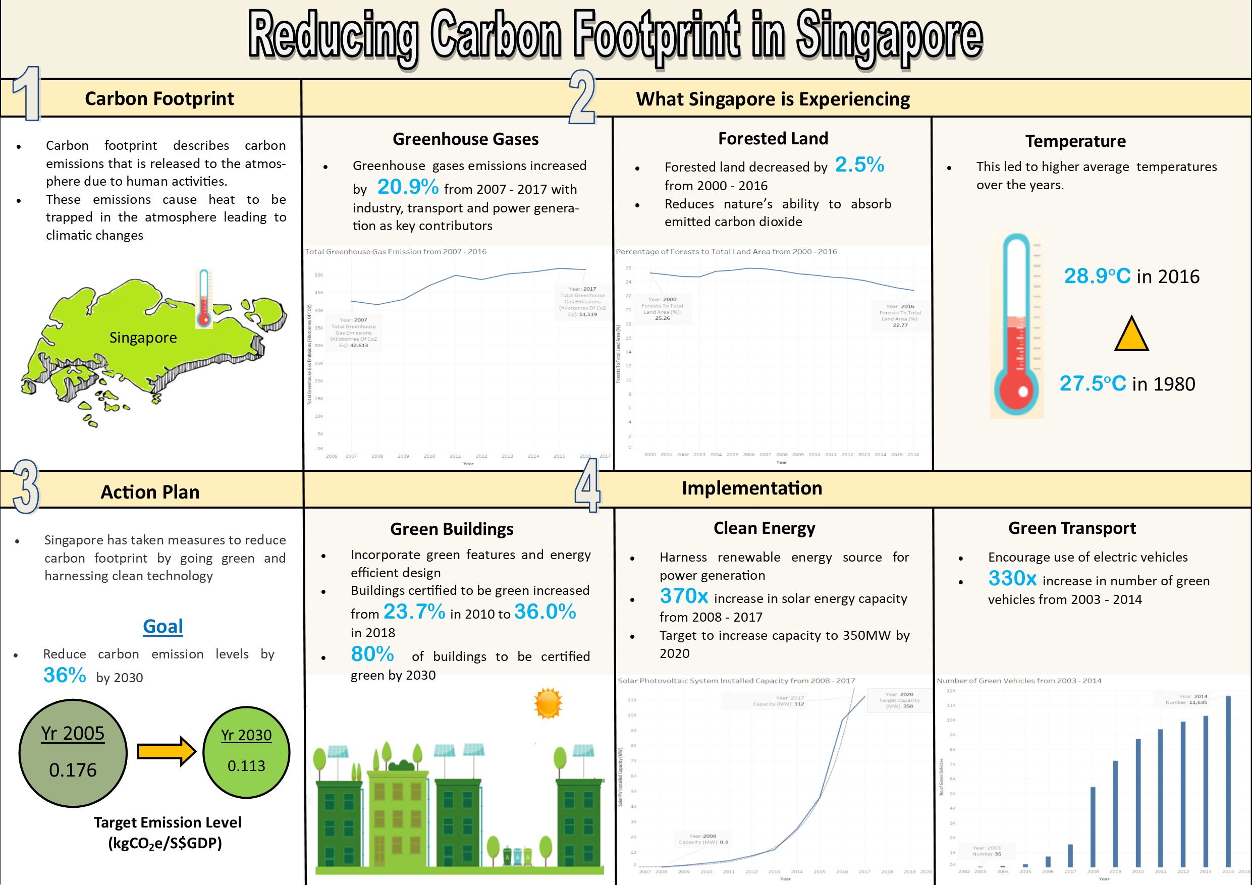
 View projectThe infographic shows the factors influencing carbon footprint in Singapore, its impact and the actions taken to reduce carbon footprint.
 -
 View projectPollution index of the world based on the factors of air, water, garbage, green spaces and parks, water accessibility, and others.
 -
 View projectA visualization of wind direction, frequency, and speed at the airports of nine major cities in the US from January to October, 2018. Cities in include New York, Charlotte, Jacksonville,...
 -
 View projectWe built an interactive map to look at the various ways that the UK sources its energy. It’s a broad subject with an elaborate system of connecting parts, but the majority of people understandably...
 -
 View projectThe Natural Resources Inventory is an interactive collection of metrics and data visualisations that depict the stock, value and use of Queensland’s natural resources. It is the world’s first...
 -
 View projectThe soil of Korea is severely polluted. The Korea soil pollution campaign has utilized infographics to visually analyze the data collected through the Soil Measurement Network provided by the...
 -
 View projectNeil And Buzz was motivated by a realization: I had no idea what happened on the Apollo 11 moonwalk beyond Neil’s "one small step." How many walks were there? How long were they out there? How far...
 -
 View projectVisual Thinking Nucleus showing dots for each tweet. The entrant has supplied multiple files for this work: [1] [2]
 -
 View projectIn 2013 Russian doctors teamed up with engineers to develop a robot‑assisted surgical system to meet the needs of both surgeons and patients. In 2018 first experimental surgery was successfully...
 -
 View projectThe increased industrialization of farm animals has not only affected the number of animals processed every year, but has also had immense environmental effects on the air, land, and water of the...
 -
 View projectOn the 1st of July, Shanghai started enforcing its compulsory domestic waste management. The city's regulation requires people to sort trash into four categories - dry garbage, wet garbage (kitchen...
 -
 View projectThe phrase "health and longevity" is what everyone wants to achieve, and it is also a good wish for the other side. We can see in many TV programs that some people do everything they can to live a...
 -
 View projectKubernetes is a rising technology in the field of DevOps. One of the outstanding issues in operating these clusters though is the complexity that comes inherently with such a complicated...
 -
 View projectAn animated data-driven documentary about climate change and public trust in science, Degrees of Uncertainty takes an inquisitive look at the complex relationship between certainty and scientific...
 -
 View projectHow do we begin to evaluate the impact of autonomous vehicles and shared mobility services on congestion? How do we embrace the uncertainty surrounding these new mobility technologies? Cities...
 -
 View projectOn the 50th anniversary of Apollo 11’s moon landing, the National Aeronautic and Space Administration (NASA) is setting its sights on returning to the moon, and going far beyond. This interactive...
 -
 View projectTo prevent climate change climate breakdown and keep global warming global heating below 3–4 degrees celsius, we have to reduce greenhouse gas emissions and transition to renewable energy –...
 -
 View project9/11 came as a gift to NSA, giving them more power and freedom to have mass surveillances illegally. And not just through eavesdropping on our phones, they’ve found a new weapon to invade our...
 -
 View projectThis infographic was a class project from my spring 2019 "Information Design" course. The project started with 'mind-mapping' on the topic of waste. I found myself feeling passionate about...
 -
 View projectThis infographic was made for class with the intent of informing anyone who views it information on bats and how important they are for people and the environment to help spread awareness to the...
 -
 View projectHumankind has been launching satellites and rockets into space for 60 years, filling Earth’s orbit with masses of debris with China’s expanding space programme a major contribution to the issue. An...
