
Inspired by the SMH article "Casino buses in migrants who hope 'to live beyond their means"(Heath Aston; December 11, 2011), we created a series of map to show the influence of The Star casino on...
-
 View project#MakeoverMonday is a social experiment run by Andy Kriebel and Andy Cotgreave. Each week Andy Kriebel shares a foreign data set and asks others to turn it into a more meaningful visualisation. The...
 -
 View projectExplore what the energy mix each state of the USA will look like with 100% renewable energy with this interactive dataviz.
 -
 View projectThis was a semester long project that was created during my studies at Fachhochschule Nordwestschweiz FHNW in Basel, Switzerland. This project shows the impacts trough deforestation. From the...
 -
 View projectdelvv.io would like to submit the graphic work from our very own Rising Star, Anja Laubsher. We are a qualitative research startup based out of Johannesburg, South Africa. We live in a continent...
 -
 View projectAfter one hundred years, how far have we pushed forward the limitation of human body? Are human races getting faster, higher and stronger? To answer this question, the project collect historical...
 -
 View projectHolobiont Urbanism is a research endeavor that sets out to study, map, and visualize the microbiome of New York City, in order to reimagine the city as more than a vast metropolis, but rather as a...
 -
 View projectQS Best Student Cities is an annual index assessing cities in five key categories: university rankings, student mix, desirability, employer activity and affordability. This infographic reports the...
 -
 View projectAt Avodato we have been collecting data about how the Internet is interconnected during the last months to do some basic data exploration and create some basic visualizations about how the internet...
 -
 View projectA visual comparison of selected (GB, US, Germany, China & Brazil) countries from around the world to highlight how different we are when it comes to our daily routines and washing habits, with...
 -
 View projectThe Swiss Post recently presented various information and resources on e-commerce. The scrollable microsite conveys the notion of e-commerce being more than just an online shop. Interdisciplinary...
 -
 View projectThis is the average day of 1,000 Americans. Using data from the American Time Use Survey, I modeled a day as a time-varying Markov chain and simulated their time to the minute. The animated...
 -
 View projectCommissioned by Someone for Cancer Research UK, a data visualisation created for the cover of CRUK's 2016 Research Annual, showing the the far-reaching collaboration between scientists all across...
 -
 View projectWe are an agency specializing in infographics and data visualization : we help companies understand and visualize data, information and communication content.
 -
 View projectThis poster was created as a piece of merchandise to accompany the Crash Course Anatomy & Physiology series on YouTube. The poster is a comprehensive and humorous look at human anatomy. The...
 -
 View projectThis infographic shows 12 foods and their popularity among our most successful users of MyFitnessPal in terms of weight loss.
 -
 View projectThe list of scheduled speakers at the Democratic National Convention is nearly twice as long and more diverse than the Republican National Convention last week. Here's how the speakers at both...
 -
 View projectAs temperatures rise and oceans warm, regions will face drastic changes and will be increasingly affected by climate hazards.
 -
 View projectA record number of women now use contraception. The latest figures from the UN’s Department of Economic and Social Affairs show 64% of married and cohabiting women used modern or traditional...
 -
 View projectRoughly 2.2 million people are locked up in prison or jail; 7 million are under correctional control, which includes parole and probation; and more than $80 billion is spent on corrections...
 -
 View projectOn the 10 of January the great musician David Bowie died. Several web portals published the lists of the critics favorite songs. So 3 very different in many ways (political views, social aspects...
 -
 View projectThe real estate market has been one of the main driving forces of China’s economy for more than one decade. This fast growing industry also contributed to social inequality in urban...
 -
 View projectThe authors scanned data from the U.S. Census Bureau’s 2014 American Community Survey—which covers 3.5 million households—to find out how people are pairing up.
 -
 View projectThe birth of the printing press not only revolutionized education and knowledge, it also reshaped the design of letterforms. This opened up a whole industry for printers-scholars, type cutters, and...
 -
 View projectCapricious Earth is big data visualization product, shows statistics from 1976-2016, more than one million global seismic data for nearly 40 years, and the earthquakes of Chinese provinces. This is...
 -
 View projectWikiverse is galactic reimagining of Wikipedia with up to 250 thousand articles to explore and discover. In this miniverse, articles are turned into stars which naturally cluster by similarity....
 -
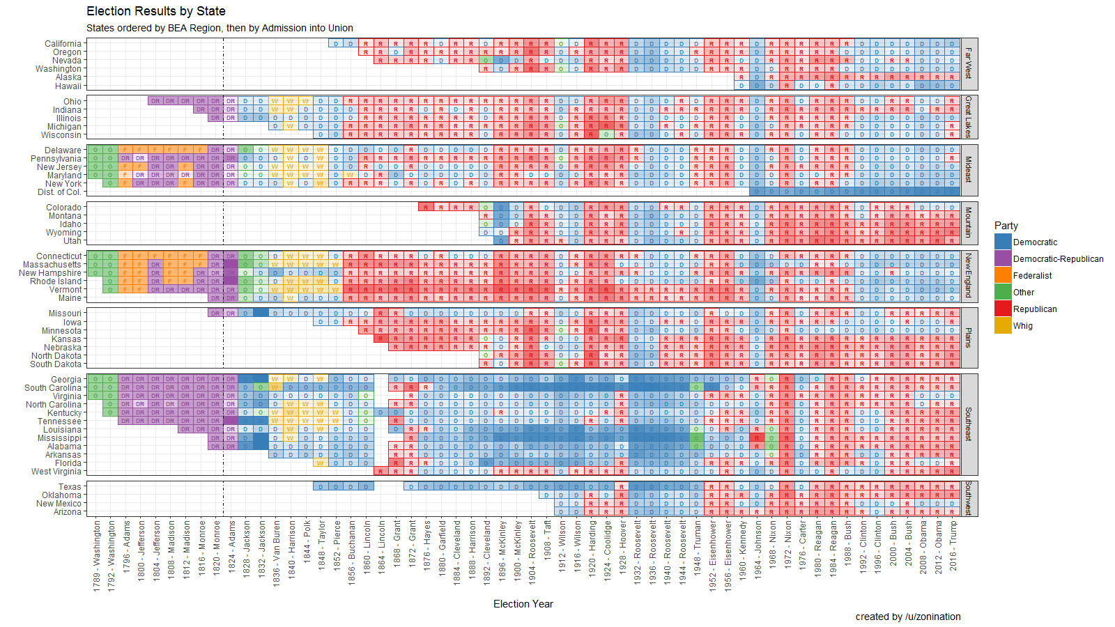
 View projectOpen Source visualization of Election Results by state, party, year, and candidate, sorted by region.


