
This year was the 50th anniversary of the Woodstock Music & Arts Fair. What was it like to experience those three days in 1969? This project examines the data from the event to try to get some...
-
 View projectPlotparade.com is an experimental chart creator tool that lets you create beautiful, unusual looking infographics from simple datasets. It offers a handful of design templates: pick one, copy and...
 -
 View projectSexual assault in America has existed for centuries, yet not at any one time has the concentration of them publicly surfaced as much as in the last quarter of 2017. Spawning #MeToo, #TimesUp and...
 -
 View project"An Atlas of Space" is a collection of ten maps designed in Python using open data from NASA and the USGS. The designs include a map of 18000 asteroids in the solar system, topographic maps of each...
 -
 View projectMarket Cafe Magazine is the world's first magazine about data visualization founded in 2017 by information designers Tiziana Alocci and Piero Zagami. Reading Market Cafe Magazine you will hear...
 -
 View projectThis series of infographics was born from my growing obsession with data visualisation and my longtime love for the show Friends. I’ve been a fan of the TV series since I was old enough to watch...
 -
 View projectThe work integrates the questions related to the game and people's psychology through questionnaires in the way of investigation, and finally presents them through dynamic posters and interactive...
 -
 View projectLess than 7,100 cheetahs exist in the world today. Poaching, illegal pet trade, lack of conservation, and low genetic diversity are a few factors impacting the fastest land animal's...
 -
 View projectOnly a handful of batsmen over the years have reached the 10,000 run milestone in limited overs international cricket. This interactive charts out how one of the modern greats, Virat Kohli, got...
 -
 View project4600: This is the number of Swiss citizens standing for one of the 200 seats in the National Council on 20 October. 2019. More than ever before. Age, gender, political attitude: these are their...
 -
 View projectSweet-to-look-at data visualizations of advertisements seen in one day. This project focuses on the execution of 3 separate data visualizations that express the same data but in very different...
 -
 View projectA revealing bubble chart... the top 20 similes used in the Bible's poetry book ‘Song of Songs’. Data was created, analysed and wire-framed before the design. It needed to be traditional and a...
 -
 View projectNowadays, tourists are more aware of rental accommodation options in their selected destinations. Airbnb has seen a phenomenal rise in Europe, and this dataviz highlights a few trends to give an...
 -
 View projectThis work is made for our client, LinkedIn Marketing Solutions Team. As the client requested, and to suit our target audiences' reading habits, it is a mobile-only version, so please watch it on a...
 -
 View projectThe Journal plotted the location of every satellite currently in orbit, charting and color coding each by use and by country of origin, to illustrate the race to profit from space. This visually...
 -
 View projectBackground: Creating visualizations that include multiple dimensions of the data while preserving spatial structure and readability is challenging. Here we demonstrate the use of geofaceting to...
 -
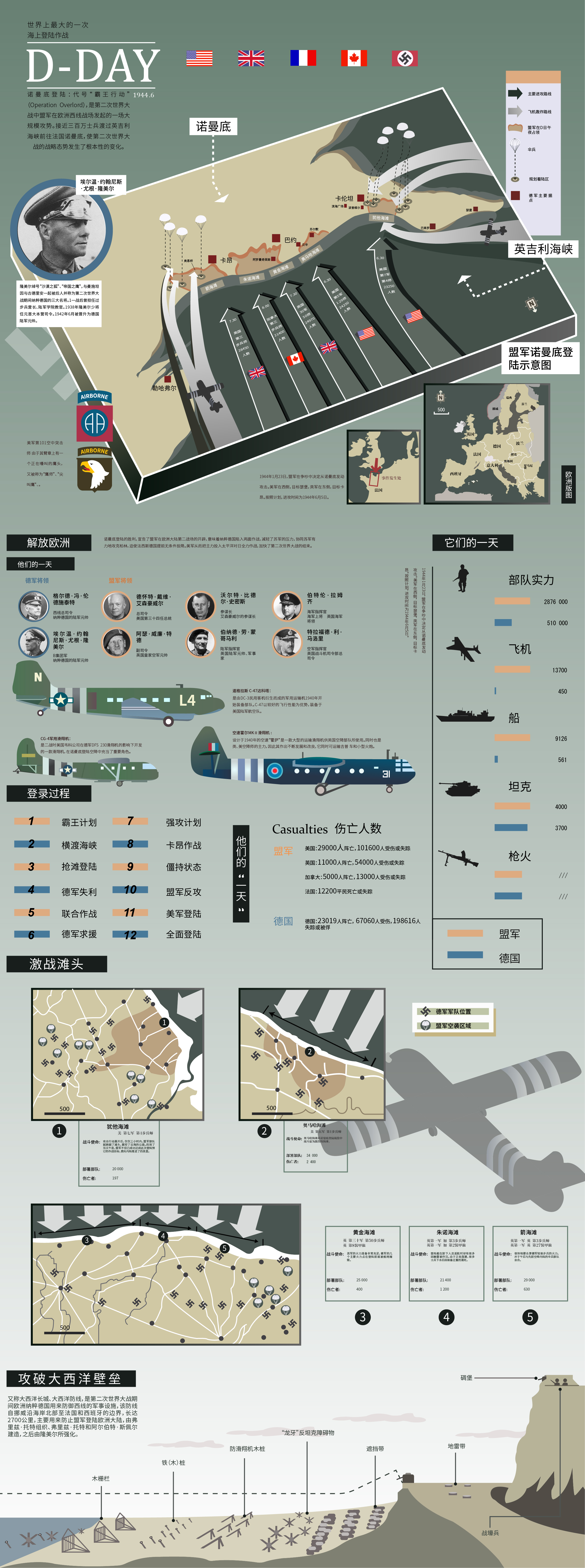
 View projectThis is my junior year's information course assignment in the last semester. At the time, I chose the historical event of Normandy landing. I learned the war and learned the greatness of this...
 -
 View projectOver the summer and autumn 2018, there was a hot debate about weapon exports in Switzerland: The Swiss Federal Council wanted to loosen the export regulation such that, in certain cases,...
 -
 View projectThis visual story compares how Hong Kong and China apply the rule of law. The gap between the two systems is laid out and both jurisdictions are compared to the best and worst countries, as tracked...
 -
 View projectSpecial about the basketball player of FC Barcelona and the Spanish team, Juan Carlos Navarro "La Bomvar Navarro" who retired this year. What started as a mere collection of data dispersed in...
 -
 View projectSince German reunification, millions of people have left the eastern part of Germany, triggering a demographic crisis. Data now shows exactly what happened – and why there’s cause for hope.
 -
 View projectThis story explains how and why hunching over your phone is destroying your posture and exposing those around you to manifold dangers. Data, diagrams, videos and animation show how and why we get...
 -
 View projectThis interactive globe shows the geology of Earth over the past 750 million years. Users can enter their locations to see where their homes are on the Pangaea supercontinent and other unique...
 -
 View projectEvery country in the world is regularly tracked by a large number of metrics. The metrics important for a “good” country are personal - see where the countries of the world fall on your personal...
 -
 View projectThe Colours of TinTin is an abstract representation of the 24 book covers of the 'Adventures of TinTin' and homage to 'Ligne Claire', a style of drawing pioneered by Belgian cartoonist Georges Remi...
 -
 View projectFor this project, am exploring the question ‘How Can Sound be Visualised?’ I am intrigued by how I can reveal the sounds around me into a visual form, and am experimenting with the ways I can do...
 -
 View projectHand-drawn infographics shows all Quentin Tarantino's movies in chronological order. It compares year & month of a premier, budget & box office, movie length & rating. Based on the...
 -
 View projectFor decades, everybody in the music business knew one thing: if you wanted to break a new artist, you had to get their songs played on the radio. But with the advent of streaming services, times...
 -
 View projectThe interactive digital special project "Mercator. It’s a Flat, Flat World" tells the story of a famous map, published in 1569 by the Flemish cartographer Gerardus Mercator. We describe the...
 -
 View projectComet in Moominland is one of the stories of Moomin books. This visualization brings together different visual analytics of the story.