
Artwork for Wired UK on UK's biggest spam service from January to August 2014
-
 View projectI picked the 24 cities based on a balancing act of the following criteria: Cities with data-rich sources (some of the best historic data happens to be provided by international airports in...
 -
 View projectBig data gets all the glory, so I set out to explore data of a much smaller and more personal nature. Little Data is an ongoing series of data visualizations based on hand-collected personal data...
 -
 View projectTo mark the completion of the Rio 2016 Olympic Games, ‘The Pursuit of Faster’ data visualisation project explores the evolution of medal winning performances across all Olympic Games since...
 -
 View projectA visual display of the varieties of tea from China and Taiwan. As the second most widely consumed beverage, second only to water, tea has a lot more varieties than you would think. Like wine where...
 -
 View projectVirtual reality has the ability to not only mimic real life, but also to transport its users to another world. The term was popularized relatively recently, in 1987 by Jaron Lanier, but the...
 -
 View projectThis poignant infographic offers an overview of the roots of racism through the centuries, trying to expose the causes of this modern scourge.
 -
 View projectAfter a bitterly contested Australian election, the returned Government of Malcolm Turnbull faces the prospect of negotiating with various blocs of other parties in order to pass its agenda through...
 -
 View projectPayPal was founded in 1998. Over the course of four years, its founders guided the online payments service provider to one of the biggest tech companies in the world, before being acquired by eBay...
 -
 View projectAfter Novak Djoković , the best-known portrait of the Western Balkans unfortunately remains mass unemployment. Especially among young people.
 -
 View projectThe clock cycles through the color wheel every 12 hours using only colors I like. The clock also changes brightness every hour so that the half-hour mark is the brightest and the hour-mark is the...
 -
 View projectDisplaying a cities density (people per square kilometre) by creating city-like typographic expressions of that density. The more crammed and taller the buildings within the boundaries of the type,...
 -
 View projectAll layers represent the duties and goals of the Ministry of Infrastructure and the Environment in The Netherlands. The bottom layer stands for a sustainable society. It's the foundation of all...
 -
 View projectOver the course of the last thirty years, more than 7 million Colombians have left their homes and towns, looking for safety away from the conflict between the guerrillas, the Colombian armed...
 -
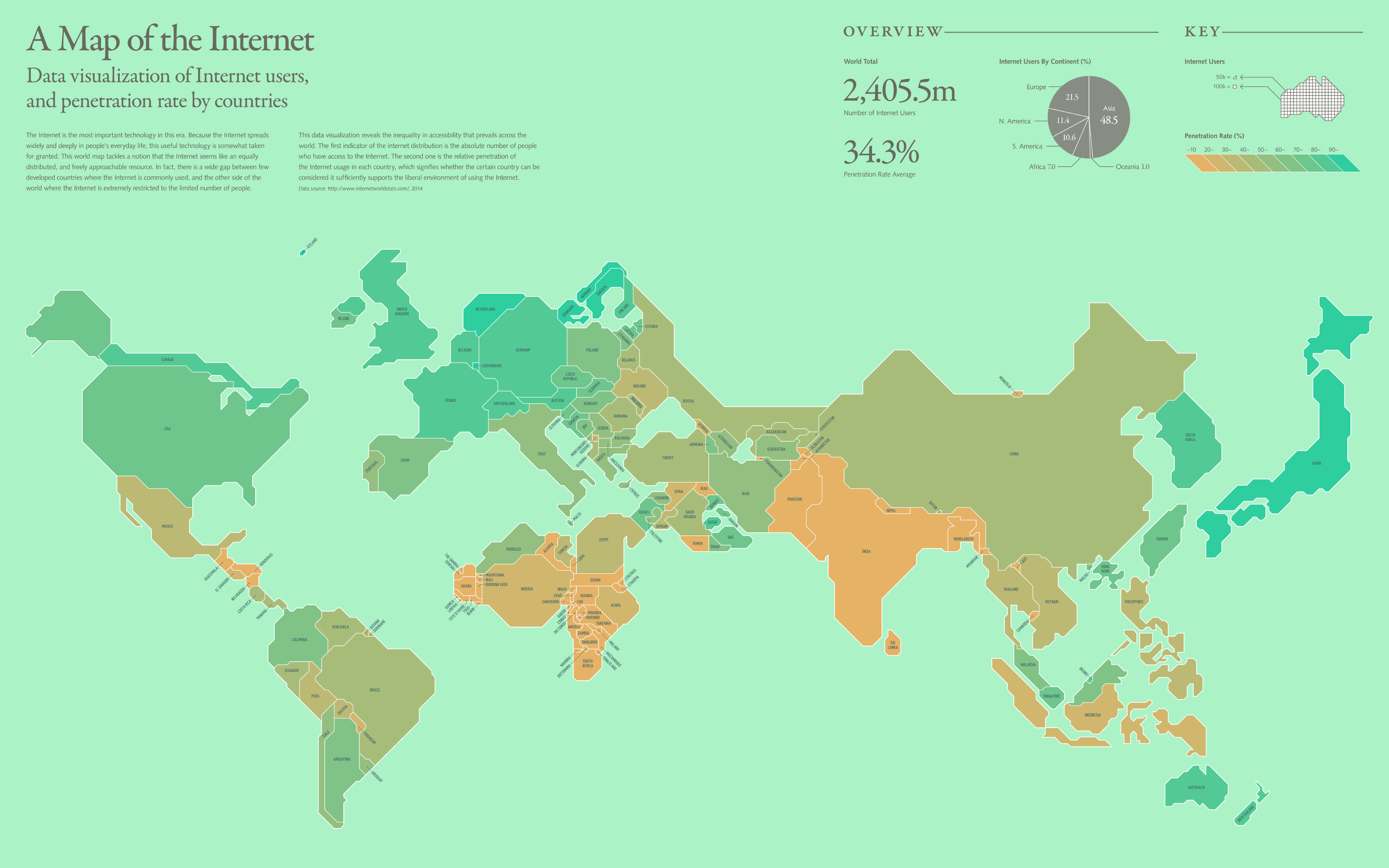
 View projectThe Internet is the most important technology in this era. Because the Internet spreads widely and deeply in people's everyday life, this useful technology is somewhat taken for granted. This world...
 -
 View projectThe artwork represents the revenues of all Star Wars episodes (in the middle), and their actors (outer circle), according both to all the films they took part in and to only those of the saga....
 -
 View projectArtwork for Il Corriere della Sera - La Lettura about the production and consumption of Pasta in the world. Source: International Pasta Organisation - The World Pasta Industry Status Report 2013
 -
 View projectA record number of women now use contraception. The latest figures from the UN’s Department of Economic and Social Affairs show 64% of married and cohabiting women used modern or traditional...
 -
 View projectDuring the 2016 Australian election, ABC News ran an interactive tool that helped voters see how their views compared to the candidates' policies. More than 1.3 million people used the tool during...
 -
 View project“We explore the relationship between life expectancy, access to doctors, and wealth. Overall the picture is that typically, wealthier nations have more doctors per person and a longer life...
 -
 View projectOur collaboration tool enables audiences at live events to brainstorm, share ideas and respond to presentations in real time. Stimulating collaborative thought, Talkviz engages audiences and...
 -
 View projectThe design work is based on my students' work of Data Visualization Design. using daily records of emotional impression, my expectations on homework, and feedback as data to make a re-information...
 -
 View projectInfographics are everywhere, but what made them so successful? This infographic exposes the science behind the boom.
 -
 View projectThe visualization effectively replaces the pdf print annual report of this society, which consisted of text and tables only and had little appeal, even though it contains important information on...
 -
 View projectAn interactive analysis revealing how the Star Wars trailers frequently repeat scenes while parsing out bits of new material to generate attention.
 -
 View projectEnglish has words from all over the world but come from three main sources: Germanic, Old French, and Latin and Greek. This visualisation color codes text based on word origins.
 -
 View projectAnyChart is a robust JavaScript/HTML5 data visualization solution for easily creating interactive graphs, maps, Gantt and stock charts, and dashboards in any project, on any platform and in any...
 -
 View projectSonnet Signatures visualizes each of Shakespeare's 154 sonnets by charting the letters used within each one. The signatures are not meant to assign meaning but to inspire others to think about...
 -
 View projectThis visualisation shows the relative deprivation of 109 cities and towns in England. The diagram has been produced by collating the ‘English Indices of Deprivation’ and the ‘Major town and city...
