
With the collapse of investment bank, Lehman Brothers, the 2008 Financial Crisis became full blown economic downturn which eventually led to the worst financial crisis since The Great Depression of...
-
 View projectThis infographic analyzes the complex historical and cultural deposits in Chinese historical relics, and specifically explores the architectural, art, and historical background of Nanjing Ming's...
 -
 View projectFor the 2018 Brazilian general elections, our team developed a highly detailed results map, segmenting the electoral results by ballot location. This may seem trivial in countries where the state...
 -
 View projectChina’s coal region has been particularly hard hit as the trend for renewable energy continues to grow, with the outflow of people compounded by low birth rates and ageing populations. We analyse...
 -
 View projectEvery year, humanity is leaking more and more plastic into the world's oceans. Plastic does not dissolve. Instead it is ground into smaller and smaller pieces at the micrometer and nanometer...
 -
 View projectThe project 'Pantheon' visualizes information about top 1000 of the globally known people born within present day the world. The visualization is based on data of Massachussets Institute of...
 -
 View projectThe Royal Dutch Cycling Federation wanted to attract more people to the fascinating sport of Freestyle BMX. Targeting live spectators and jury members, we developed an engaging platform that...
 -
 View projectFor decades, everybody in the music business knew one thing: if you wanted to break a new artist, you had to get their songs played on the radio. But with the advent of streaming services, times...
 -
 View projectChinese traditional roof decoration style, variety, and in the long history through the changes of the complex and the fusion, so in different regions, different nationalities and different...
 -
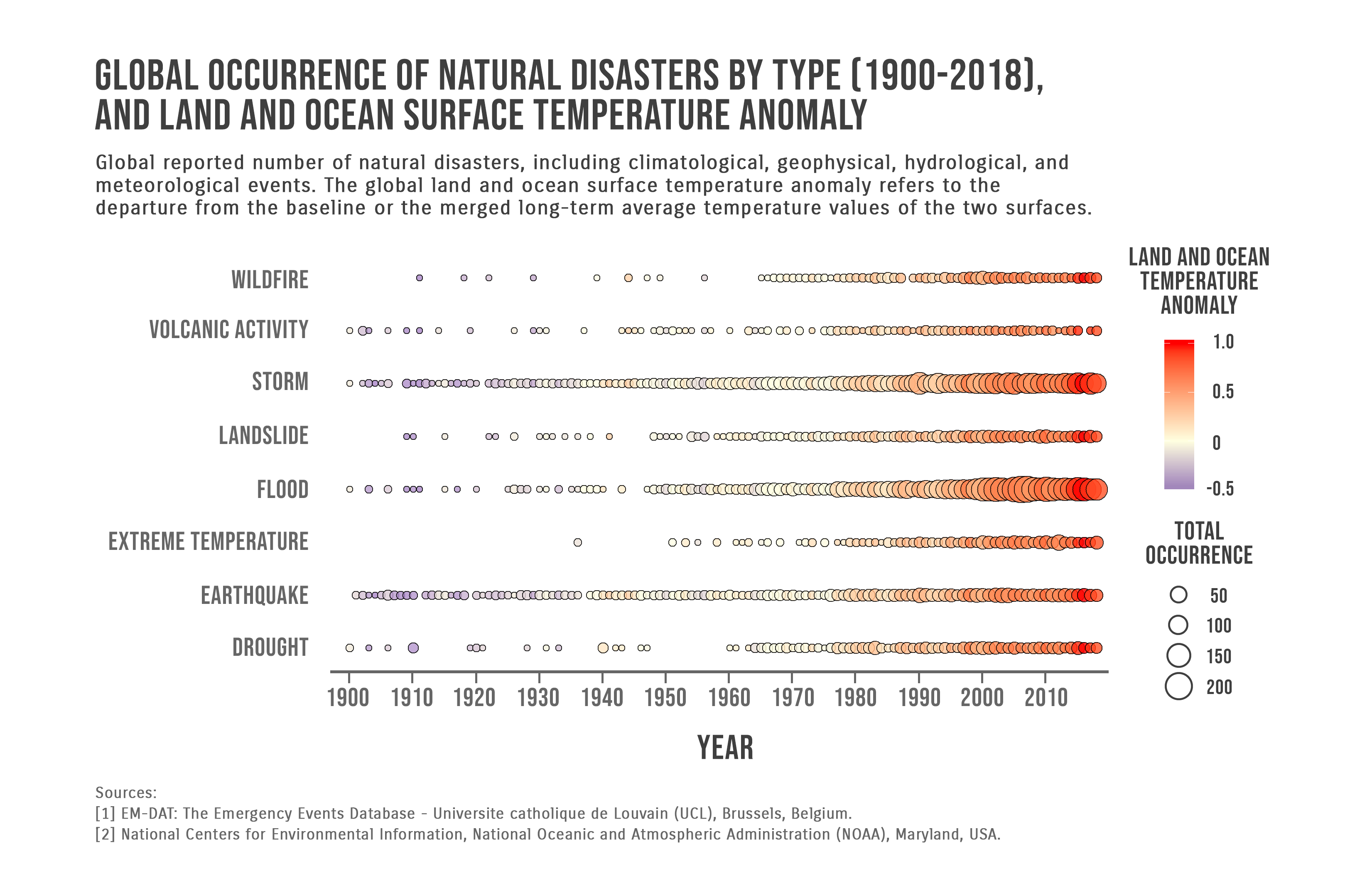
 View projectGlobal reported number of natural disasters, including climatological, geophysical, hydrological, and meteorological events. The global land and ocean surface temperature anomaly refers to the...
 -
 View projectThe goal of this project is to align the viewer’s choice of products and actions with their personal goals. There's so much unknown around ingredients used in our products, and this infographic is...
 -
 View projectOn April 20, 1999, the United States where shocked by the High School school shooting and attempted bombing in Columbine, CO. It caused 15 fatalities (12 students, one teacher, and two...
 -
 View projectGermany would have made the cut, Australia would have topped its group and Argentina would be on their way home – using expected goals, we calculated what the knockout stages of the 2018 football...
 -
 View projectWhy did human development proceed at such different rates on various continents? I used the data and the theory presented by Jared Diamond to make this project to let people easily know his...
 -
 View projectTo celebrate the 50th anniversary of the most giant leap for mankind, we visualise all the missions to the Moon.
 -
 View projectUnconsciously, the name "small steel teeth" has been with me for nearly two years, from the initial worry, tension, and some unacceptable; To later slowly adapt to slowly accustomed, and then to...
 -
 View projectLooking at the 24 teams to have won titles across the various English first division football league incarnations since 1888.
 -
 View projectAlso women can harass men in different type of ways, but it seems that no one is willing to talk about it. Just like concrete, men are stereotypically considered strong, unbreakable. Bu exactly...
 -
 View projectWhat does eight decades of design look like? Launched in celebration of Knoll’s 80th anniversary, The Archive is an interactive website celebrating the rich history of the iconic design firm. Users...
 -
 View projectThis visualisation is to understand the current trends of students' adherence to the cuisine of their ethnicity in comparison to what they had in childhood when their parents cooked for them. It...
 -
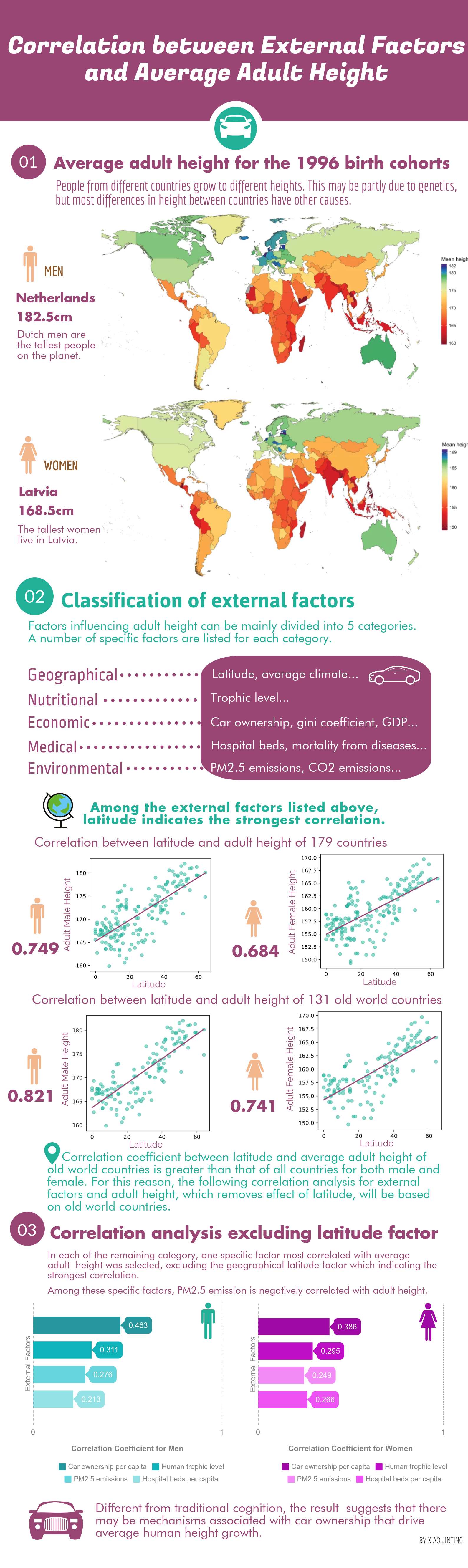
 View projectThe infographic shows that, after excluding the geographical latitude factor which indicated the strongest correlation, the most significant correlation was between per capita car ownership and...
 -
 View projectPlanet’s goal of imaging the entirety of the Earth every day became achievable with the unprecedented fleet of small satellites, called “doves”. The animation showcases one day in the life of these...
 -
 View projectMass shooting fatalities have dramatically increased in the United States over the last ten years. We are still in mid-2019, and we count 25 deaths in 4 incidents. This visualization shows the...
 -
 View projectThe western winds and the North-Atlantic ocean current make the European winter a relatively mild one, but this season still comes in many different shapes accross the continent. Explore them all...
 -
 View projectImagine a world where machines can be controlled by thought alone. This is the promise of brain-computer interfaces (BCIs)—using computers to decode and translate human thoughts into machine...
 -
 View projectEach winter, a thick blanket of smog settles over vast swathes of northern India, including the capital, New Delhi. As wind speeds drop and nights get cooler, the problem is exacerbated as polluted...


