
While horses have come close in recent years, none have come close to replicating the winning form of Affirmed or Secretariat, perhaps the most famous horse of all time. Activ8Social takes a closer...
-
 View projectR. Crumb was responsible for sparking the underground comix (with an x) revolution of the '60s and '70s that brought satirical and adult-themed titles into the mainstream. He was one of the most...
 -
 View project#Observasegurança is a non-profit public safety data visualization tool. With millions of data points comprising 4 different databases - including ones that have never before been made public -...
 -
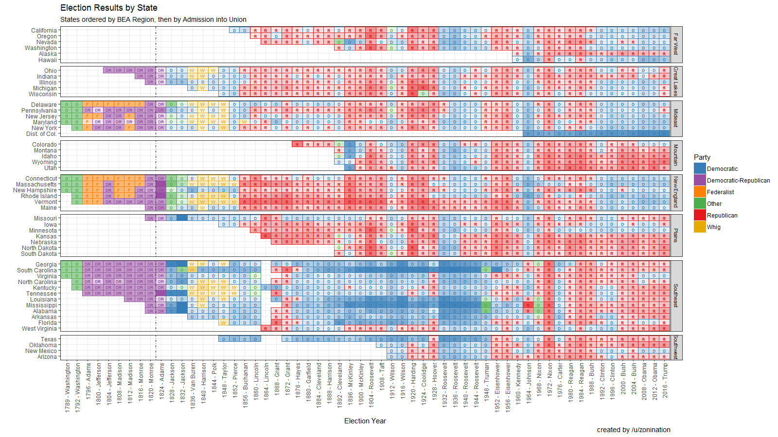
 View projectOpen Source visualization of Election Results by state, party, year, and candidate, sorted by region.
 -
 View projectMachine Learning has garnered significant public interest in recent years, prompting professionals worldwide to acquire skills in this field. Yandex Researches team undertook an educational...
 -
 View projectHow much does a pack of Marlboro typically cost in Boston, MA? Which city has the most expensive McMeal? As the most expensive city in the U.S., is everything in New York City overpriced compared...
 -
 View projectMichael Schur was involved in the creation of 4 top hit TV shows - The Office, Parks and Recreation, Brooklyn 99 and The Good Place. This visualisation looks at cast members who featured...
 -
 View projectThe second part of “A Visual Introduction to Machine Learning” series, this installment describes a tradeoff fundamental to machine learning and artificial intelligence. Using scroll-linked...
 -
 View projectReleased in April this year, How far is it to Mars? is an Interactive infographic based around one beautifully simple concept: Showing the distance between the Earth and Mars as a long scrolling...
 -
 View projectNot all markets are the same, nor are individuals. TNS took a comparative look at the four personas of the connected consumer in the UK and China for our 2014 Connected Life campaign, showing that...
 -
 View projectI love space and science! This work was inspired by my own curiosity and love for space. It has such a cyclical magical feel that transcends our small blip of existence. You can see that with the...
 -
 View projectThe Beijing-Tianjin-Hebei region, located in northern China, consists of Beijing and Tianjin, two directly governed municipalities, along with parts of Hebei Province. This region serves as China’s...
 -
 View projectThis visual app makes CO2 goals tangible on the personal level: What can you change in your own household to contribute to the 40% reduction of CO2 emissions that the Dutch government has promised...
 -
 View projectThis visualization explores the growth in Las Vegas hotel room inventory, from 1970 to 2018. It highlights notable hotels which have opened and closed during that time, and how they in turn...
 -
 View projectBauhaus Sound App (available on apple store and play store) The Bauhaus Sound Tool augments the exhibitions and buildings of the Bauhaus Dessau with the dimension of sound. This real-time...
 -
 View projectThis graphic conveys to the reader which countries, by economic size, are at what stage in their central bank digital currency (CBDC) research, development, and implementation process. The larger...
 -
 View projectIntuitive interactive maps & charts visualising an extensive & authoritative database of international trade in natural resources. Chatham House’s resource trade database reorganizes UN...
 -
 View projectWhat happens when the maps that millions of Americans rely on to make informed decisions about flood risk are rife with inaccuracies? "Outdated and Unreliable: FEMA's Faulty Flood Maps Put...
 -
 View projectBack on Planet Earth, we at Nominet have been looking for a way to visualise global internet use. The result is our map of the online world, an atlas redrawn according to the number of...
 -
 View projectTitle: 2024 World Economic Forum Travel & Tourism Development Index: Regional Performance Trends Description: This interactive dashboard highlights the rankings and performance shifts of...
 -
 View project“Quaran.tiles” is the physical representation of a collection of expressive geotags created on Instagram in 2020 as a response to quarantines during the first wave of infections of COVID-19. Due to...
 -
 View projectInvestigate the structure and operational flow of the 500-meter radio telescope FAST. The components mainly include cable support system, cable net structure, active reflector panel system,...
 -
 View projectEvery day, New York City’s 5.5 million commuters seed the city subways with bacteria from the food they eat, the pets or plants they keep, and their shoes, sneezes and unwashed hands. No two subway...
 -
 View projectI created this 3D visualization entirely in R, using the rayrender package (a software package that I also wrote and have released to the community). I also used the geojsonsf R package to convert...
 -
 View projectData Visualization based on the "Democracy Index", a report made by The Economist Intelligence Unit, which assesses and provides an overview of the freedom levels of authoritarian and democratic...
 -
 View projectMenstruation is a subject where data remains surprisingly vague — dominated by averages that fail to capture the individual realities of those who menstruate. This gap inspired the creation of a...
 -
 View project–Attention Radar' is a web app that visualizes large data sets monitoring political agendas of the Netherlands and the European Union. The data was collected by Montesquieu Institute in The Hague...
 -
 View projectCybersecurity content is often in service of a product. It is a young industry built on top of funding rounds, valuations and products. As an end user of cyber security solutions, it's not always...
 -
 View projectRemember all 1,352 shots the Chicago Blackhwks used to win the Stanley Cup, hockey's championship trophy? We do.
 -
 View projectInfographics are everywhere, but what made them so successful? This infographic exposes the science behind the boom.