
‘Waste World’ is a multi-dimensional globe visualization that shows how the layer of the world looks like if we compare countries by their waste generation…
The Globe:
The height of the country...
-
 View projectForest fires is an important problem that affects both the natural and built environment as well as the inhabitants of these areas in various ways. Forest fires, which can occur as a result of...
 -
 View projectThe article explores the historical significance of the rubber industry in Singapore and its deep-rooted impact on the present discourse surrounding migrant workers in the country. As recent as...
 -
 View project"The Names on the Moon" is a stroll on the lunar surface through its feature names. We always see the Moon portrayed as a muted grey sphere orbiting planet Earth, marked by dark spots visible to...
 -
 View projectMore frequent and intense extreme heat is one of the major impacts of climate change. To assess how the incidence of extreme heat has changed over time, Carbon Brief examined which regions...
 -
 View projectWhat is the definition of drought? The drought problem due to climate change is frequently in the news. But what exactly is drought? When I consult the site of KNMI (The Royal Netherlands...
 -
 View projectThe Wandering House ~ Sonic Archive, is a repository of testimonials and ambient sounds gathered by artist and filmmaker, Cecilia Cornejo Sotelo, through her multimodal project, The Wandering...
 -
 View projectClimate justice means being fair to all, especially when dealing with climate change. The world is getting hotter, causing illness, destructive weather events, and financial difficulties. The...
 -
 View projectAccording to the article "The Lifecycle of Plastics" by WWF Australia, a disposable baby diaper takes 500 years to completely decompose on Earth. When I first came across this new knowledge, I was...
 -
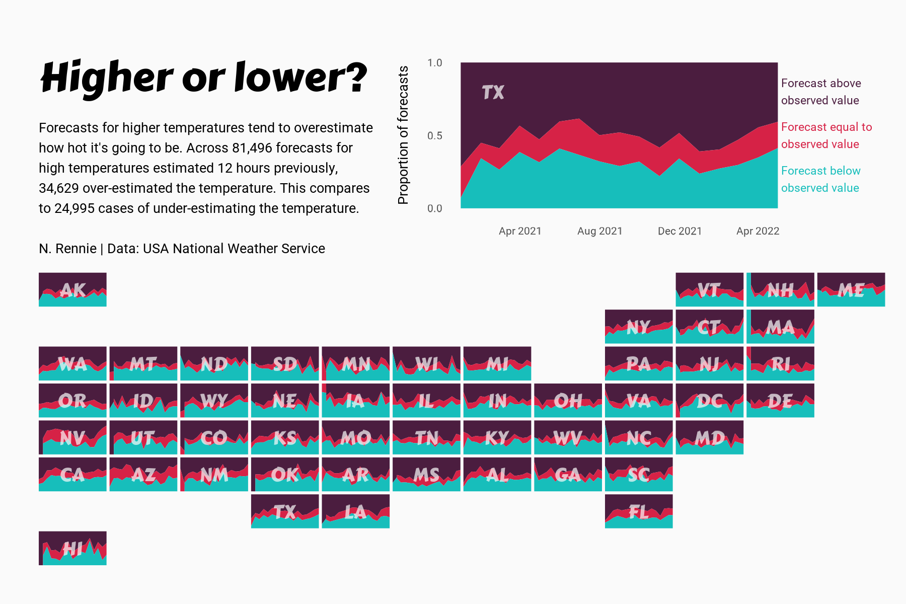
 View projectThis chart visualises the accuracy of high temperature forecasts made by the USA National Weather Service between January 2021 and June 2022, within a 12 hour window. Proportional area charts show...
 -
 View projectUrban trees matter to everyone, but especial children. This visualization looks at the American Forest's Tree Equity Score data set for Los Angeles through the lens of kids and their...
 -
 View projectA map of Senja, Lofoten & Vesterålen with touches of personal data to remember the five months I traveled through Norway in 2022 with my partner. I loved the whole country, but these locations...
 -
 View projectHow do you define the neighborhoods in your city? Axios created an interactive game that lets readers draw boundaries for select neighborhoods in their city and compare their responses to the...
 -
 View projectThe in-house bakery makes hundreds of bakery products each day for the students to consume them but a lot of people do know about it. This data helps to understand the different products produced...
 -
 View projectSince the nuclear accident caused by a powerful earthquake in 2011, Japan has been storing a huge amount of contaminated wastewater in the Fukushima Daiichi Nuclear Power Plant. Now that it almost...
 -
 View projectThis is a infographic providing information about different types of tiles used in a design college building.
 -
 View projectI have created an infographic designed for the primary audience of head staff members who navigate their Excel spreadsheets to assign rooms to new employees at the university. This visual aid aims...
 -
 View projectThe Infographic show important details about the mess in the university campus for the students.
 -
 View projectClimate Change in Data is a layered digital narrative that uses the power of words, visuals, and videos to guide readers through the key findings of one of the most significant IPCC climate reports...
 -
 View projectA network map showing all of the New York City Subway Lines and ranking of line by length of line and number of stations along line.
 -
 View project“World Heritage in Danger 2023” is an information design and data visualization project with an aim to raise awareness of decaying beauty in our world with a skeptical overtone. The data...
 -
 View projectWhen geometry and human intuition meet: What becomes of the intersection between pragmatic visual tools and emotion? Everybody worries about something. Worrying is an act of the everyday that...
 -
 View projectThis visualization shows a cluster of colleges under MIT ADT university and the number of people working under various departments through graphs.
 -
 View projectThis interactive narrative aims to illustrate the contrasting disparities in the lives and opportunities of children in Eastern and Western Europe, using the metaphor of children's books. Not all...
 -
 View projectThis visualization represents the correlations between the 10 key factors in the smart city rankings published by Eden Strategy Institute in their Top 50 Smart City Government Ranking 2020/2021...
 -
 View projectEnvironmentalists have warned for decades that Mekong River dams were threatening the natural flow of sediment – a centuries-old system delivering nutrient-rich mud down the 5,000-km waterway to...
 -
 View projectService design methodologies can support the design of ad hoc visualisation tools focused on user needs. We present a case study co-development of a visualisation tool for the analysis of public...
 -
 View projectWe commemorate 150th anniversary of the unification of Buda, Pest and Óbuda into Budapest with a series of 50 alternative maps, mainly produced from open source or publicly available data. The maps...
 -
 View projectThis infographic charts the 3 highest mountains on each of the seven continents across the world. The visualization shows isometric illustration of the 1st highest of all the continents, and uses...
