
The map and chronology of Chinese history take the map and chronology of Chinese history as the main information chart. We mark the major historical events and times of relevant geographical...
-
 View projectA visualization of the primary roads of the Roman Empire, circa 150 AD, in the style of a subway diagram. Connections between cities are emphasized at the expense of topographical accuracy. The...
 -
 View projectIn the words of Bill de Blasio and his team members, the New York City government would be at the brink of definitively rooting out crime, that is to say putting an end to all forms of violence...
 -
 View projectIt is a work done from the Jihadist attack in Barcelona during the month of August. The infographic explains the tour of the terrorists on La Rambla in Barcelona and the places most frequented by...
 -
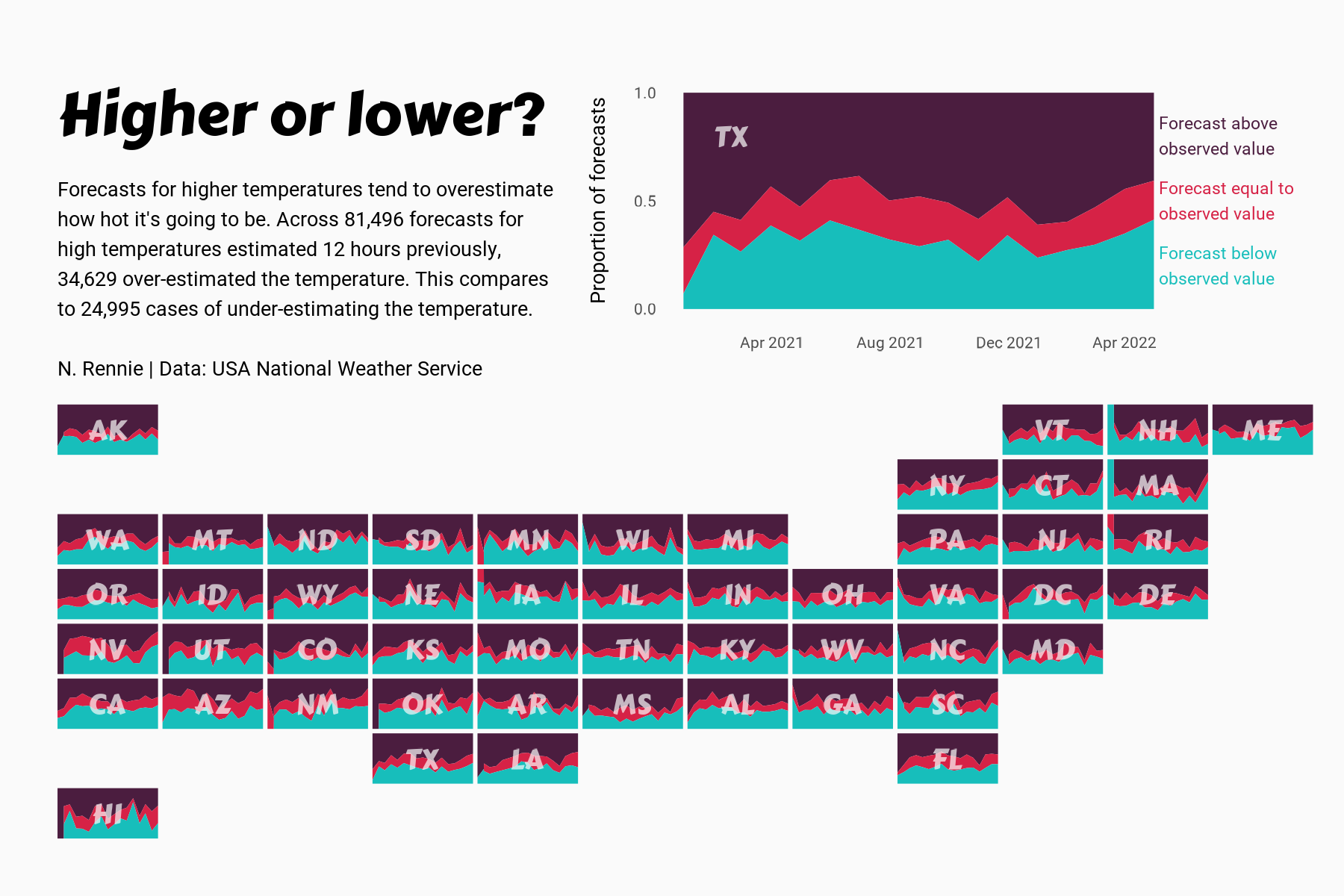
 View projectThis chart visualises the accuracy of high temperature forecasts made by the USA National Weather Service between January 2021 and June 2022, within a 12 hour window. Proportional area charts show...
 -
 View projectTransitFlow is an open-source software tool that enables users to easily generate spatial-temporal visualizations of transit frequency in cities around the world!
 -
 View projectThe one trillion tonne iceberg, measuring 5,800 square km, calved away from the Larsen C Ice Shelf in Antarctica sometime between July 10 and 12, scientists said.
 -
 View projectAn interactive map of Moscow in which you can explore the different periods and styles of architecture. In this work I wanted to share the architectural variety of Moscow, demonstrating through...
 -
 View projectHeartbeats. is an info-art piece to make the heartbeats of animals visible and audible. More than 150 species of animals are going extinct every day. Perhaps considering the beating, breathing...
 -
 View projectThe project of a fantasy subway in Rome meeting the main famous buildings and monuments in more than 2700 years of history. They are 8 tematic lines about historic periods: (L1) Ancient Roman...
 -
 View projectThe in-house bakery makes hundreds of bakery products each day for the students to consume them but a lot of people do know about it. This data helps to understand the different products produced...
 -
 View projectOur methodology, termed as "streetonomics", is a form of computational social science that studies human behavior and cultural trends through the quantitative analysis of street...
 -
 View projectIs the pathetic fallacy of a Nightingale singing in Berkeley Square threatened? This visualisation aims to find out.
 -
 View projectA lot of people move to Dubai, an emirate in United Arab Emirates, to start their own business and live the entrepreneurial life, given the relatively low corporate tax rates as well as the 0% tax...
 -
 View projectInteractive visualisation that can be used to view average CO2 emissions of cities worldwide at a glance, as well as to dive into the data for a specific city – both its emissions and trends over...
 -
 View projectI took the gps positions of vehicles from a small route here in Toronto and graphed them as dots progressing around a circle instead of dots on a map. Then I change the radius of the circle to...
 -
 View projectEver noticed what’s outside a classroom window? Schools in Austin can apply for City of Austin grants for school-based projects that could include up to eight environmental areas. These areas...
 -
 View projectIt’s very easy to become overwhelmed by the climate emergency, the numbers quoted in news reports are so immense and the steps needed to genuinely tackle it seem so overwhelming. We wanted to...
 -
 View projectVideo documentation: https://vimeo.com/751860865 How did people live in the 8th century? In an impressive way, users of the interactive application "Viking Walks" embark on a digital tour of...
 -
 View projectThe report presents the generation, collection and treatment of waste in Mexico City. This process is represented in a data visualization that shows how many tons of waste are generated by the city...
 -
 View projectLanguage is an extension of individual identity, as vocabulary is freely chosen on social, cultural, and economic base. This map presents the Digital Humanities Conference 2019 through its...
 -
 View projectThis data visualization gallery shows the sunrise and sunset times around the world. See how the night and daylight areas change during a two year period. To focus on the length of nights the y...
 -
 View projectAn immersive motion-sensitive experience showing the disastrous impact of plastic in our oceans. The Blue Paradox is a powerful and thought-provoking exhibit that raises awareness of the plastic...
 -
 View projectHow has the UK – cradle of the industrial revolution – nearly ended its reliance on coal? Carbon Brief tells this story of unprecedented change in a scrolling graphical narrative that maps every...
 -
 View projectOver the last few hundred years, maps have divided territory into political administrative units (countries, states, etc.). Newer spatial realities, however, are driven by the flow or inhibition of...
 -
 View projectA comprehensive travel report on Airbnb - breaking down how it works, and highlighting the facts, figures and culture of the company.
 -
 View projectHow do you define the neighborhoods in your city? Axios created an interactive game that lets readers draw boundaries for select neighborhoods in their city and compare their responses to the...
 -
 View projectOur noise maps show the levels of exposure to noise in London, Paris and New York. Use your mouse to explore the loudest and quietest spots. We’ve created this to help people learn more about noise...
 -
 View projectIn November 2021, the foreign minister of Tuvalu addressed the climate summit COP26 while standing knee-deep in the ocean to raise awareness of the imminent threat sea level rise represents for...
