
These ‘Monsoon Rainfall Clocks’ describe the monthly rainfall totals between 1905-2015 for India, Bangladesh, Myanmar and the UK. Each gradated coloured curve represents one year, its distance from...
-
 View projectEnvironmentalists have warned for decades that Mekong River dams were threatening the natural flow of sediment – a centuries-old system delivering nutrient-rich mud down the 5,000-km waterway to...
 -
 View projectMany of humanity’s most challenging issues are shaped by cross-border forces. To address, and report on, these issues, collaboration is critical. That is why the University of Miami and Universidad...
 -
 View projectThe Wandering House ~ Sonic Archive, is a repository of testimonials and ambient sounds gathered by artist and filmmaker, Cecilia Cornejo Sotelo, through her multimodal project, The Wandering...
 -
 View projectThe Nakaiy Almanac visually merges indigenous knowledge and weather data, showcasing the value of an intricate and historic understanding of weather patterns and of emerging changes in weather...
 -
 View projectSeries of infographics on the lack of sustainability of nuclear energy for the magazine "Energy & Environment". On six pages, the graphics are devoted to exciting facts and problematic aspects...
 -
 View projectAfter buying a house in the Catskills in April 2022, I wanted to create a meadow garden with native plants. I wanted to plant suitable for my planting zone, 5b, and add color and interest to my...
 -
 View projectClimate Change in Data is a layered digital narrative that uses the power of words, visuals, and videos to guide readers through the key findings of one of the most significant IPCC climate reports...
 -
 View projectDuring winter 2022-2023 California experienced record snowfall, with some areas receiving over 20m (65ft). This map illustrates this snowfall thematically using 50 sq km hex-bins that each show the...
 -
 View projectThis project uses an interactive 3D globe with over 1,000 relatively evenly distributed points over Earth's landmasses to tell the story of climate change. You can animate each point's temperature...
 -
 View projectThe visualization was made for the TidyTuesday weekly challenge. I experimented with different kind of maps and charts. I ended up using points on a spiral, which reminds of a tornado and shows the...
 -
 View projectHow do you define the neighborhoods in your city? Axios created an interactive game that lets readers draw boundaries for select neighborhoods in their city and compare their responses to the...
 -
 View projectI did a survey and observed cycles in and around my college campus based on their condition if they are geared or non-geared, where they are located, whether they are locked or not and much more....
 -
 View projectWidow fountains, also known as green dragons, are iconic fixtures in Milan, Italy. Since 1931, the Lamperti foundries have produced and maintained these distinctive fountains. Standing at 1.55...
 -
 View projectUrban trees matter to everyone, but especial children. This visualization looks at the American Forest's Tree Equity Score data set for Los Angeles through the lens of kids and their...
 -
 View projectIn the US alone, we throw away 400 million paper coffee cups a day. That’s the equivalent of the volume of 13 Empire State Buildings of waste. In response to this staggering issue of waste, I...
 -
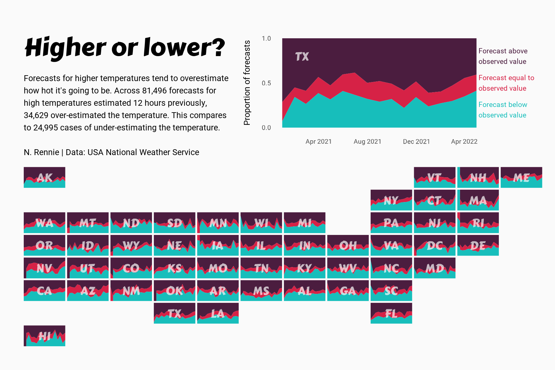
 View projectThis chart visualises the accuracy of high temperature forecasts made by the USA National Weather Service between January 2021 and June 2022, within a 12 hour window. Proportional area charts show...
 -
 View projectThis quilt was designed utilizing a data set from Our World In Data, which tracked the increase in animals killed every year for meat production. In the quilt, red = cows, orange = pigs, and yellow...
 -
 View projectTrading the Fragile: An Insight into the CITES and IUCN databases is a data-driven project aiming to shed light on the work of these two organizations. By highlighting the most traded species...
 -
 View projectThis interactive narrative aims to illustrate the contrasting disparities in the lives and opportunities of children in Eastern and Western Europe, using the metaphor of children's books. Not all...
 -
 View projectIn November 2021, the foreign minister of Tuvalu addressed the climate summit COP26 while standing knee-deep in the ocean to raise awareness of the imminent threat sea level rise represents for...
 -
 View projectCurbing global warming, halting the loss of biodiversity, and building a just and equitable economy are among the world’s most pressing needs. To track progress and reveal systemic obstacles to...
 -
 View project‘Inspiring a Movement: The Warming Stripes’ is a visualisation depicting and evaluation how Ed Hawkin’s famous ‘Warming Stripes’ graphic has grown over the last 4 years, becoming a global symbol of...
 -
 View projectThe in-house bakery makes hundreds of bakery products each day for the students to consume them but a lot of people do know about it. This data helps to understand the different products produced...
 -
 View projectWashington state has a rainy reputation. But let's put that to the test. This visualization uses precipitation data from over 100 weather collection stations for the year 2020 (~30k points), which...
 -
 View projectA multi-angle analysis of the 2022 UK housing market, which breaks the (positively-skewed) dataset into quartile groups based on house price with a top outliers group for the stately homes and...
 -
 View projectThe UNICEF Global Database on School-Age Digital Connectivity tracks the percentage of children 3 to 17 who have internet connectivity at home. The United Kingdom has the highest percentage at...
 -
 View projectAn immersive motion-sensitive experience showing the disastrous impact of plastic in our oceans. The Blue Paradox is a powerful and thought-provoking exhibit that raises awareness of the plastic...
 -
 View projectHumans grow and waste food at a staggering scale. We devote half the earth’s habitable land to food production, while ultimately tossing one-third of that food. Simply using the food we grow and...
