
I did a survey and observed cycles in and around my college campus based on their condition if they are geared or non-geared, where they are located, whether they are locked or not and much more....
-
 View projectWe commemorate 150th anniversary of the unification of Buda, Pest and Óbuda into Budapest with a series of 50 alternative maps, mainly produced from open source or publicly available data. The maps...
 -
 View project‘Inspiring a Movement: The Warming Stripes’ is a visualisation depicting and evaluation how Ed Hawkin’s famous ‘Warming Stripes’ graphic has grown over the last 4 years, becoming a global symbol of...
 -
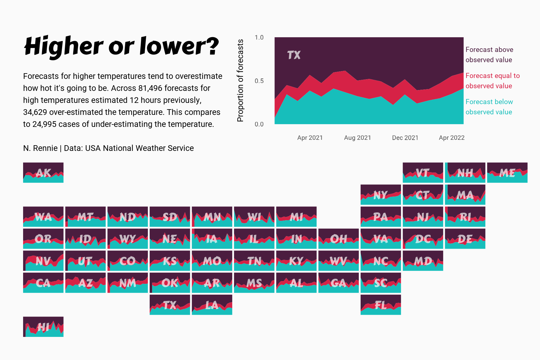
 View projectThis chart visualises the accuracy of high temperature forecasts made by the USA National Weather Service between January 2021 and June 2022, within a 12 hour window. Proportional area charts show...
 -
 View projectthe placement of cctv cameras in the college campus and how many cases are solved through it. Data of solved, unsolved and total cases as well as the types of camera used in the campus and their...
 -
 View projectThe UNICEF Global Database on School-Age Digital Connectivity tracks the percentage of children 3 to 17 who have internet connectivity at home. The United Kingdom has the highest percentage at...
 -
 View projectThe island of Hawaii (also known as Hawaii's "Big Island") is made of five volcanoes. This map visualizes these volcanoes in a simple, straightforward, and stylized way — the volcanic peak (center...
 -
 View projectThe article explores the historical significance of the rubber industry in Singapore and its deep-rooted impact on the present discourse surrounding migrant workers in the country. As recent as...
 -
 View projectIn the summer of 2022, the water levels in the Yangtze, China’s largest river, hit a record low due to low rainfall in the river basin, reduced water flowing in from its upper reaches, and hotter...
 -
 View projectHumans grow and waste food at a staggering scale. We devote half the earth’s habitable land to food production, while ultimately tossing one-third of that food. Simply using the food we grow and...
 -
 View projectHot air balloon model by LowPolyBenjamin from CGTrader. Video: https://youtu.be/4rNZxua2_qE #MapboxGL #MapTiler #ThreeJS #WebGL #3D #maps #buildings #hotair #balloons #fly #nyc #manhattan...
 -
 View projectWe compare land prices in different cities to find out what kind of home you could buy (and, above all, what size) after collecting the prize from the Christmas Special Draw and paying the...
 -
 View projectThis exploration is done as a school project for the data analytics and visualization program at MICA (Maryland Institute College of Art). This work is not affiliated with the Bird Life...
 -
 View project“Breaking point” is a multimedia story that provides an in-depth, data-driven look at the global shipbreaking industry. Drawing on thousands of manually compiled records, interviews, and firsthand...
 -
 View projectThis interactive narrative aims to illustrate the contrasting disparities in the lives and opportunities of children in Eastern and Western Europe, using the metaphor of children's books. Not all...
 -
 View projectAustralia is home to an incredibly diverse range of native plant species, many of which are found nowhere else in the world due to the continent's isolation and unique ecosystems. The exact...
 -
 View projectIn the US alone, we throw away 400 million paper coffee cups a day. That’s the equivalent of the volume of 13 Empire State Buildings of waste. In response to this staggering issue of waste, I...
 -
 View projectThe project attempts to understand the water consumption in the Design hostels. The data was collected with the help of the warden of the hostels and the plumbers who maintain the same. The...
 -
 View projectTo showcase the newcomers for hostel vacancy and warden can easily identify the number of rooms capacity left in the design.
 -
 View projectSankey diagrams show the distribution of households according to security experience and household income, the frequency of interruption of water supply according to income, and the frequency...
 -
 View projectAfter buying a house in the Catskills in April 2022, I wanted to create a meadow garden with native plants. I wanted to plant suitable for my planting zone, 5b, and add color and interest to my...
 -
 View projectThe U.S. is filled with towns and cities that were named after foreign places: You can take a trip to Naples, N.Y., or Paris, Texas. — and go on a world tour without ever leaving your home state....
 -
 View projectThis data visualization explores the main milestones in the quest to summit the tallest mountain in the world, Mount Everest. Over the decades this pursuit has become synonymous with our...
 -
 View projectThese ‘Monsoon Rainfall Clocks’ describe the monthly rainfall totals between 1905-2015 for India, Bangladesh, Myanmar and the UK. Each gradated coloured curve represents one year, its distance from...
 -
 View projectCurbing global warming, halting the loss of biodiversity, and building a just and equitable economy are among the world’s most pressing needs. To track progress and reveal systemic obstacles to...
 -
 View projectA visual summary of the the percent year-over-year change during each month in 2020 across 11 sectors. Data on retail sales comes from the US Census Bureau's Monthly State Retail Sales data product...
 -
 View projectAn immersive motion-sensitive experience showing the disastrous impact of plastic in our oceans. The Blue Paradox is a powerful and thought-provoking exhibit that raises awareness of the plastic...
 -
 View projectHousing availability in cities across America is failing to keep up with growing populations. To address this crisis, policymakers have begun to reconsider local zoning laws - the rules that limit...
 -
 View projectThis is an infographic on India's wildlife sanctuaries and parks, and covers 1> Number of sanctuaries and parks 2> Zone-wise, state-wise and area 3> year of their establishment
